Across the Plains
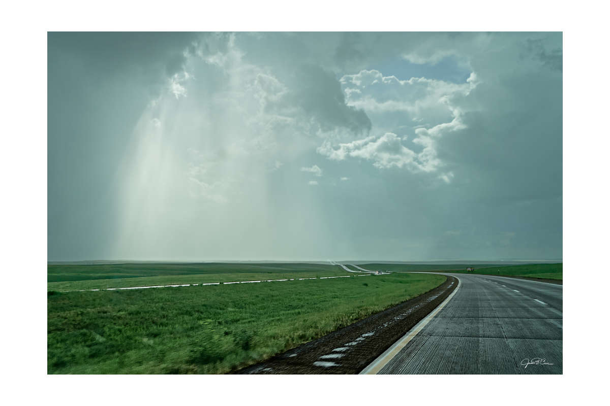
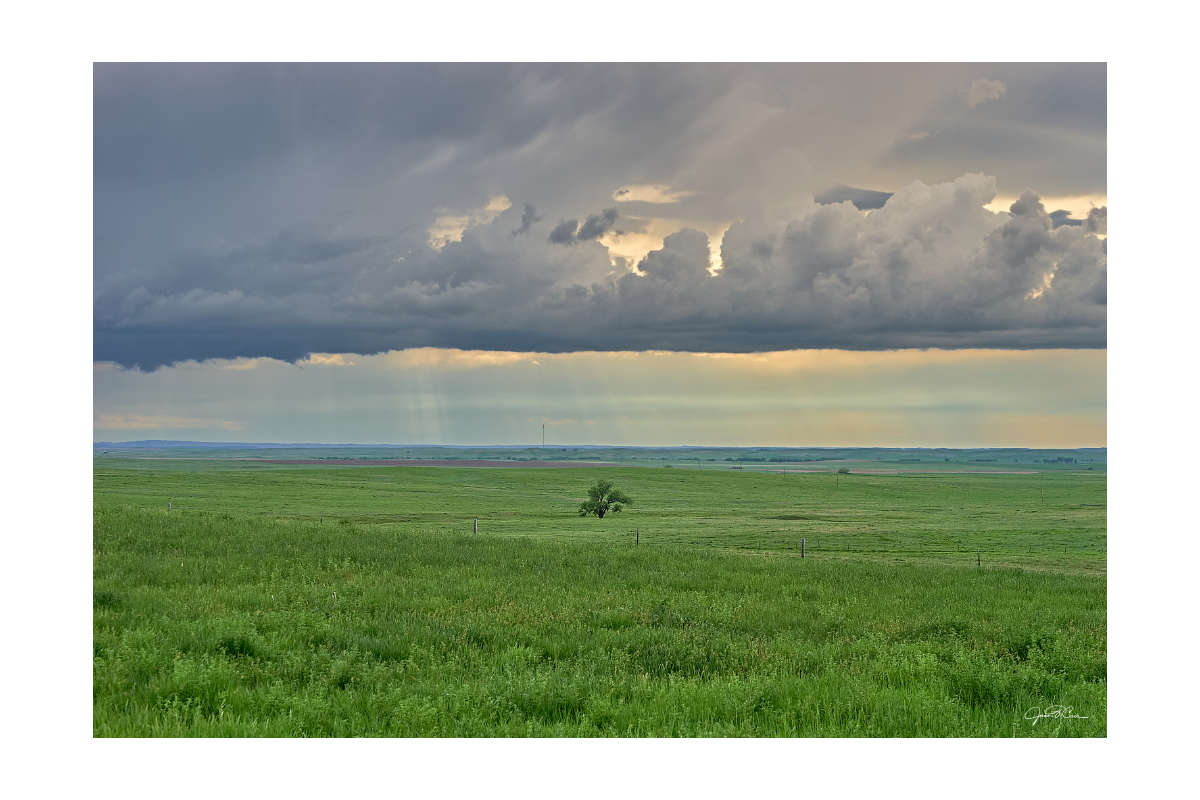
Crossing the central plains can be a lonely experience, even on a major route like Interstate 90 during Memorial Day weekend. The flatness of middle America can also be uncomfortable for someone who grew up on the western slope of the Allegheny Mountains. There is a feeling of exposure that you rarely get in Appalachia. The wonder of watching giant thunderheads roll across the prairie is both amazing and unsettling. As it turned out, Mother Nature had some surprises for me on this trip. Clouds and rain haunted me through much of the first two days of travel through Ohio, Indiana, Illinois, Wisconsin, Minnesota, and South Dakota.
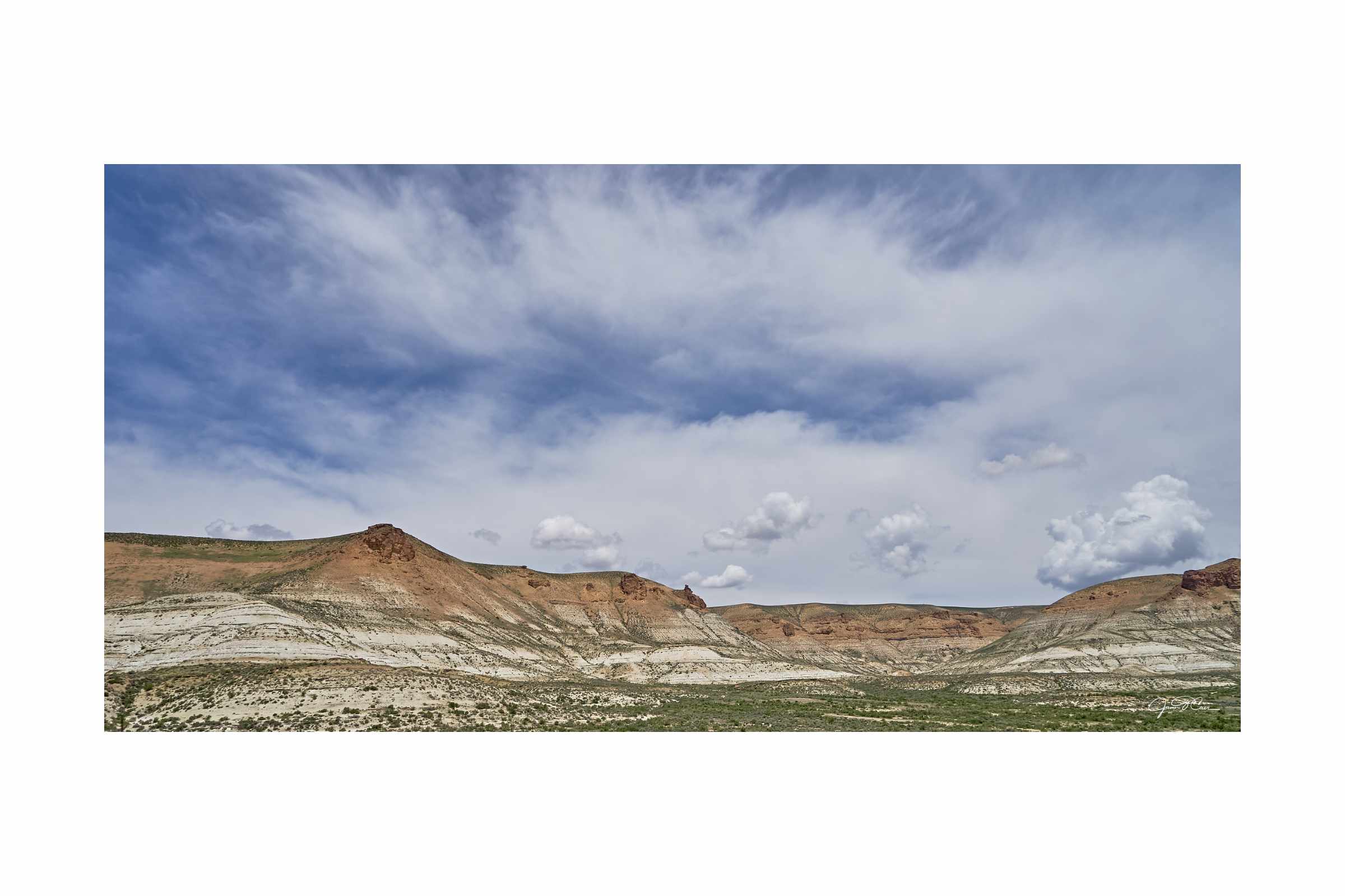
Badlands National Park
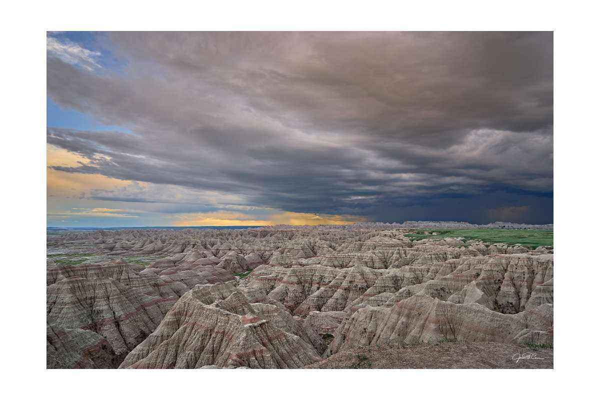
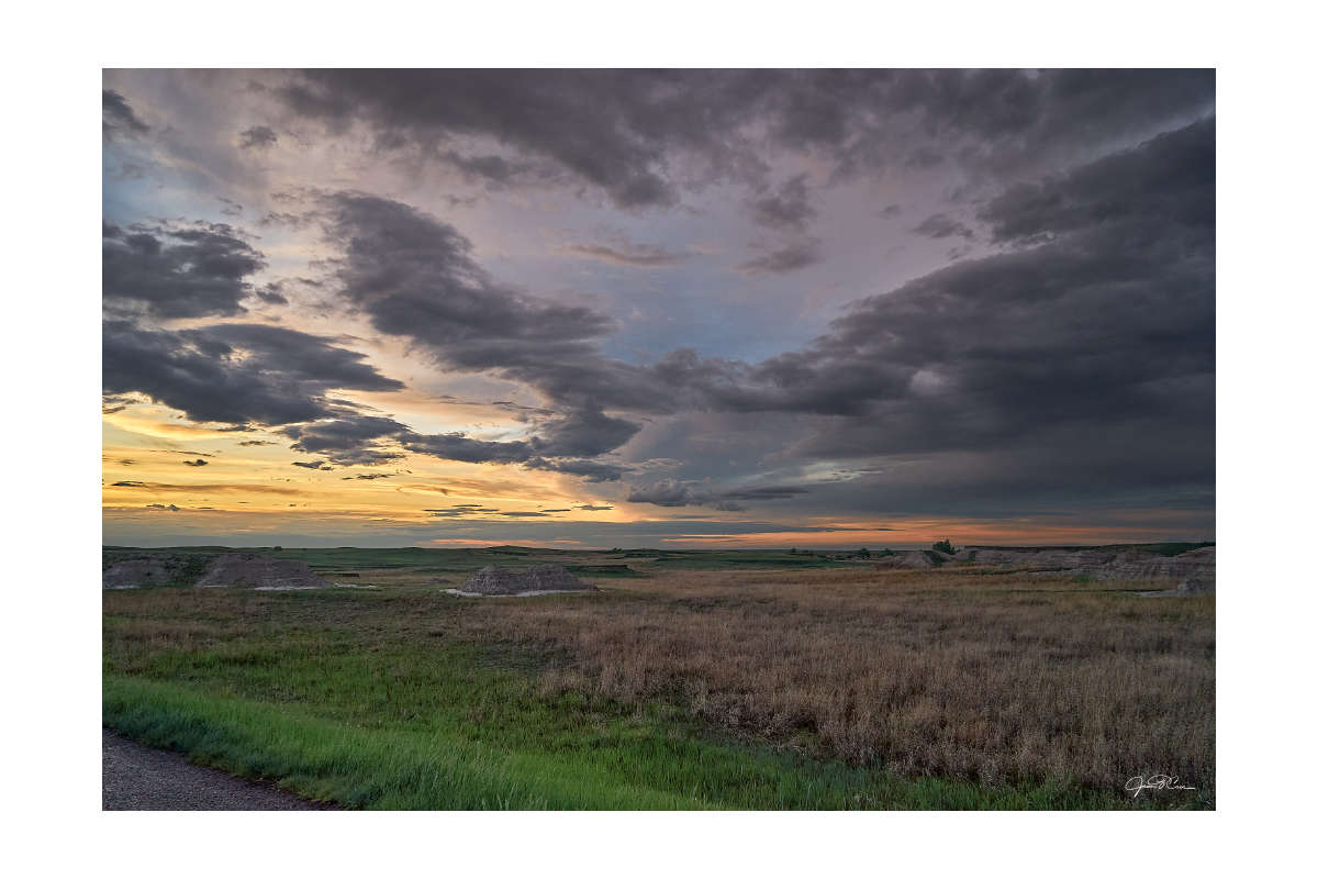
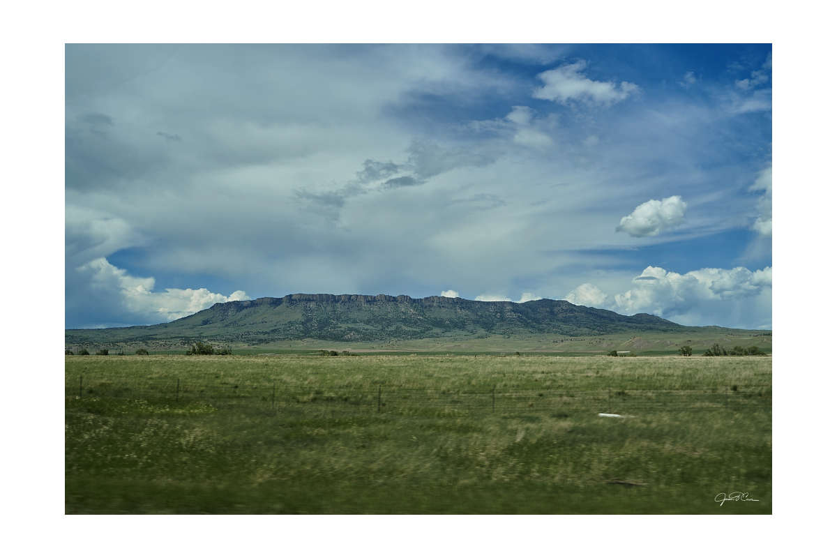
After the hours of flatlands, the gently rolling hills of western South Dakota were a sight for sore eyes. Large commercial farms gave way to ranches, then rolling grasslands as I drew nearer to my first major destination. The dull grey skies also began to give way to thick black clouds that unleashed walls of heavy rain that hung like curtains across the landscape. The occasional flash of lightning would brighten the road ahead. I was beginning to worry that the weather would ruin my late afternoon visit to Badlands National Park.
After driving through pouring rain on more than one occasion, there was a break in the weather as I approached the last rest area before the Badlands. I stopped to stretch my legs and to look back at the storm I had just driven through. It would be long before the pinnacles and canyons of the Badlands would begin to appear in the distance. I would make one more quick stop enjoy a scenic overlook of the Buffalo Gap National Grassland.
As it turned out, it would be an amazing time to explore Badlands National Park. The storms remained to the west of the park and made for a spectacular backdrop to the otherworldly landscape. It would also seem to deter other visitors, leaving me to explore mostly by myself.
Read more about my visit to Badlands National Park
One of my best decisions on my trip was purchasing the National Parks Pass when I entered Badlands National Park. It was a phenomenal value as I explored the western United States.
Mount Rushmore and the Black Hills
The landscape changed dramatically as I drove west on Interstate 90 from the Badlands. The hills grew larger and larger and evergreen trees became more abundant. After fueling up in Rapid City, I drove into one of the worst storms I’ve ever experienced. The sky turned black and quarter-sized hail pelted my car. I was briefly concerned that my windshield would be broken. After a minute, though, the storm passed. With a few small dents added to the previous damage to my car, the travel gods were appeased and I moved on.
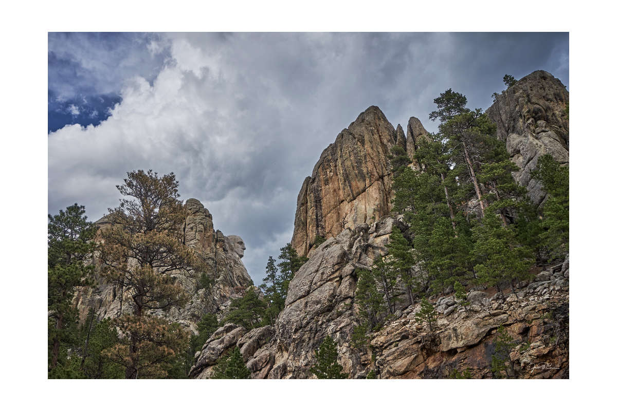
The geology changed dramatically as I wound through the hills on US Route 16 (Mount Rushmore Road). Large granite formations sprouted from the hillsides around. After rounding a turn, Mount Rushmore sprang into view. It is almost certainly what brings most visitors to the Black Hills. It’s an interesting sight but a bit of an imposition on the landscape for my tastes. I found myself much more enthralled with the surrounding natural features. I explored the area around the monument for another fifteen or twenty minutes, then headed down the Peter Norbeck Scenic Byway to my next destination.
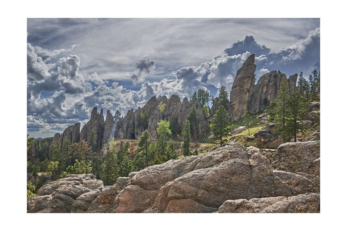
After winding my way along the two-lane road and through narrow tunnels cut into the granite hillsides, I finally arrived at Custer State Park, Home of the Needles Highway. This was the place I most wanted to experience in the Black Hills. I paid a fee to enter the park and began my ascent up the mountain. I was soon surrounded by huge blocks and spires (the “needles”) of granite. More tunnels were carved into the rock and cars patiently waited as they went through, one by one. Near the top of the road, the view opened up and I could see the rolling black hills, framed by the granite outcrops around me. It was a beautiful way to experience the area. I even had the opportunity to see a mountain goat foraging among the rocks.
After a day chockfull of exploring Badlands National Park and the Black Hills, I meandered my way back out to Interstate 90 via Spearfish Canyon Scenic Byway. It was late in the day and the sun was just illuminating the tops of the high rock walls along the winding stream and two-lane road. It was a perfect conclusion to my time in the Black Hills.
Devils Tower National Monument
Wyoming is amazing. Unfortunately, it was a much smaller part of my trip than I had hoped. Two weeks isn’t much time for a cross-country roadtrip and Memorial Day is still a little too unpredictable when it comes to weather in high elevations. The northeast corner of the state and the landscape along Interstate 80 on my sprint home would be the extent of my sightseeing. The former was the location of one of my main destinations, though.
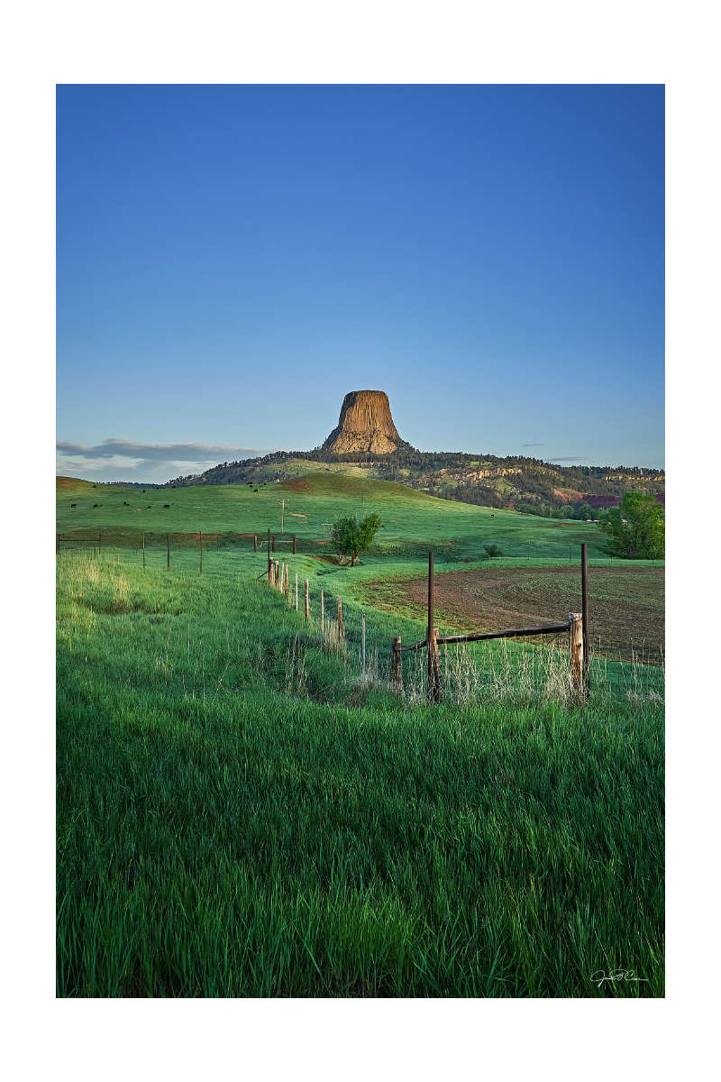
If you grew up in the late ’70s or early ’80s, there are a few US landmarks that might be etched into your memory by the popular culture of the era. Two of my main goals on this trip were to see the iconic rocks from the films I loved as a kid. The first was Haystack Rock on Cannon Beach, Oregon from The Goonies. The second was Devils Tower from Close Encounters of the Third Kind. The beauty of Devils Tower is only rivaled by its peculiarity, which made it the perfect location for the final scene of such an iconic film.
My goal was to arrive for sunrise. After a few hours of sleep at a Wyoming rest area, I was up at 4 AM for my drive north from Sundance. The monolith’s unmistakable silhouette would begin to appear in the distance, just as the early morning darkness began to give way to the blue hour. I arrived at a popular viewing location along Route 24 just as the sun was beginning to warm the horizon. Had I known better, I would have moved up the road a bit to catch the eastern side of the tower as the sun broke over the hills. Sometimes, though, no amount of planning can completely prepare you for the moment. You have to make the most of what you find.
It was so early that I didn’t have a chance to do anything but admire the view from outside the gates of the park. Nothing would open for at least another two hours and it was time to move on to my next destination.
Montana & Glacier National Park
Everything about Montana is big, and it’s big in a way that I had never experienced. Living most of my life in West Virginia, you can’t really see very far unless you are on top of a pretty big mountain. Even then, there really isn’t much to indicate how far away anything is. The top of a mountain mostly provides a view of the tops of other mountains. When you drive across the plains, you know you can see for miles, but there really isn’t much to see. One mile might as well be one thousand miles. In Montana, though, you really see and how big the world is.
Not far west of Billings, the landscape became more dramatic. Massive buttes grew out of the otherwise flat landscape. It seemed like I drove next to some of them forever. Rocky mountains would suddenly appear in the distance and slowly grow, then shrink and disappear into the horizon. The pattern repeated throughout the day as I continued along Interstate 90. As far as interstates go, 90 offers some amazing vistas. I was ready for a change, though.
My earlier route between Custer State Park and Spearfish Canyon included driving on an unpaved road. It wouldn’t be the last time. I eventually decided to leave the interstate in favor of more comfortable routes that wound Northwest toward Glacier National Park. In retrospect, it would have been quicker to stick to 90.
The road through Helena offered some of the most expansive views of my trip. Following US Route 287 along the Missouri River takes you through a wide plain flanked by large mountain ranges far off in the distance. The mountains provide a sense of scale and distance that deepens appreciation for the vastness of the landscape. I would encounter this, over and over, during my drive to Glacier. I would also experience a sense of remoteness that I had never felt before.
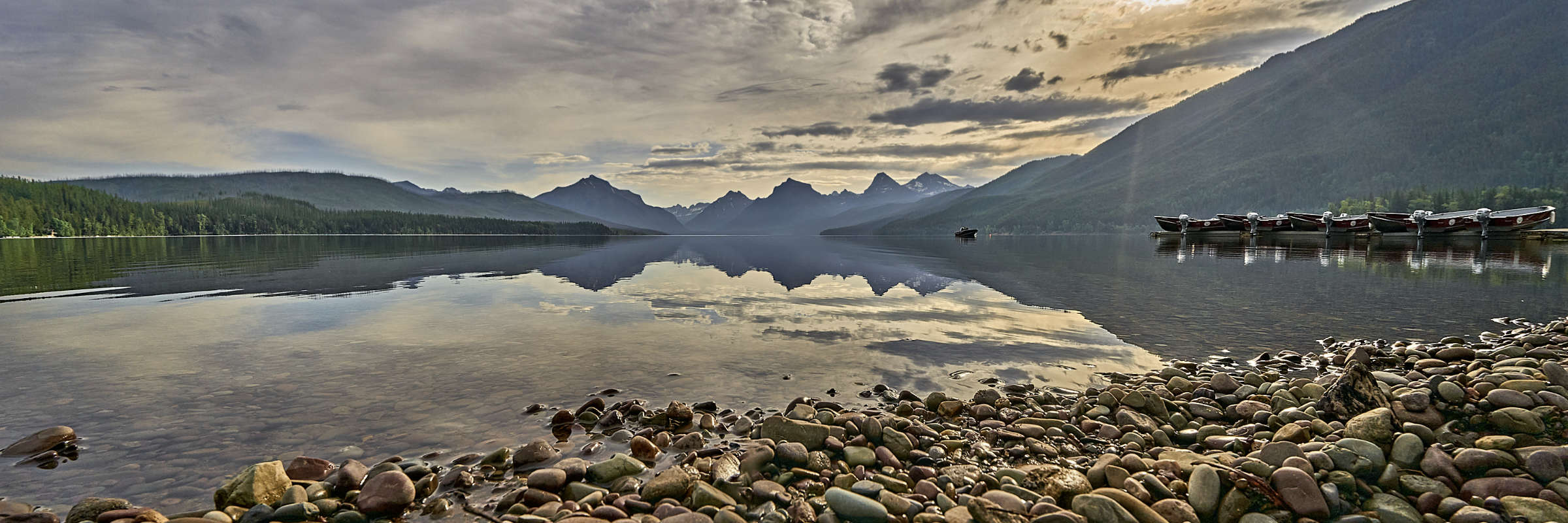
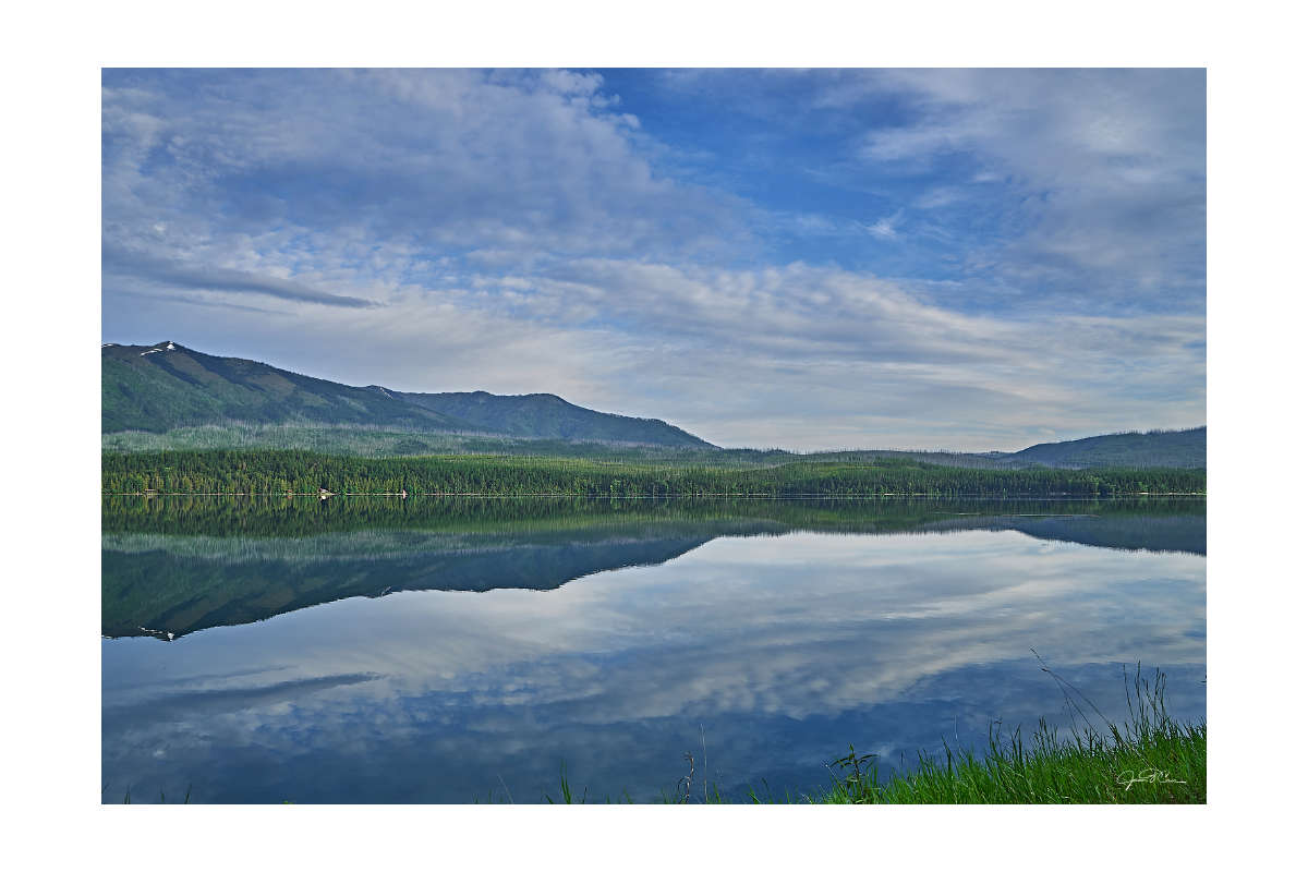
After boondocking at Hungry Horse Reservoir, I was up before sunrise for a very short visit to Lake MacDonald. May 31 is still pretty early for a visit to Glacier National Park, and Road construction and the threat of avalanches on Driving to the Sun Road had the main route through the park closed. My exploration was confined to the southern rim of the lake and the area around Apgar Village. It was enough to whet my appetite for another visit in the future, though, and this panorama from the rocky shoreline of Lake McDonald is one of my favorite images from my trip.
Idaho and Eastern Washington
Lake Pend Orielle in Idaho had been on my list of must-see places for over a decade. One of my relatives, who lives in the community of Lakeview, had piqued my interest by sharing photos of the area. My trip would be a chance to both visit her and to see this spectacular location for myself.
I drove around the north end of Lake Pend Orielle on my way from Glacier National Park. The lake is huge, so even after reaching the city of Sandpoint, I still had to drive another thirty miles to meet my cousin for the long, harrowing drive to Lakeview. I left my car near Bayview and we traveled by four-wheel drive up the mountains at the Southeast corner of the lake. My timing here was also perfect, as the dirt and gravel roads had only recently become easily passable after the winter thaw. It was beautiful but also treacherous. The hillsides were steep and the roads were narrow with no guardrails. Meeting another vehicle was an adventure. Finally, an hour after leaving my car, we arrived at the cottage in Lakeview. I visited for two days, enjoying the peacefulness of the secluded community and exploring the spectacular vistas. It was a great opportunity to slow down after a whirlwind tour of South Dakota, Wyoming, and Montana. When I left, I was ready for more adventure.
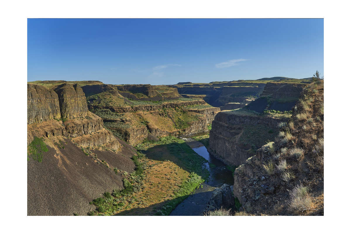
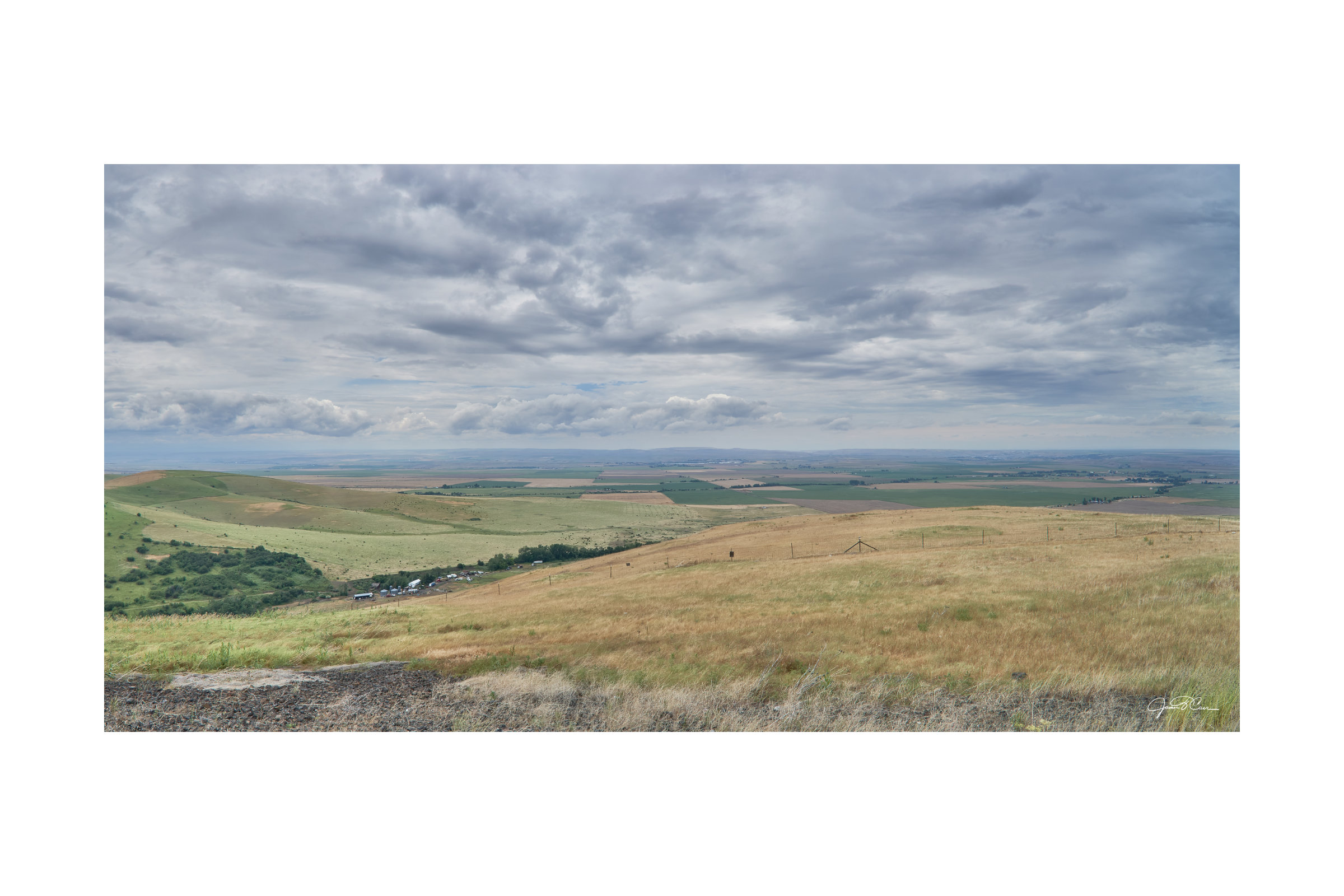
There were so many things I wanted to see in eastern Washington. Time wasn’t on my side, though, and I had already been on the road for a week. I considered forgoing my stops in the Palouse region. I made my final decision at the last minute, taking the last practical exit to head south toward the Palouse Hills and Palouse Falls. I knew of the region because of the significant geological occurrences that took place there at the end of the last ice age. It’s an amazing story that I won’t go into here, but much of the landscape of eastern Washington was shaped rapidly and dramatically by these events, thousands of years ago.
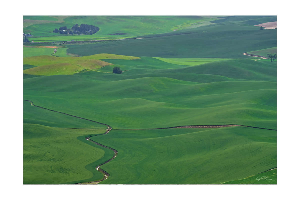
My first stop was Steptoe Butte in the middle of the Palouse Hills. The region is known for its soft undulating landscape that is also prime farmland. As the fields are planted and grow, the landscape takes on the appearance of a large multi-color quilt rippling out over the countryside. Even in early May, the view was amazing, with a patchwork of young crops and freshly tilled fields. I gained a great perspective from atop Steptoe Butte, the highest point in the area. I would love to visit this place at different times of the year and at different times of the day. It is a favorite location for landscape photographers.
My next stop could not be more different. Palouse Falls isn’t far from the Palouse Hills, but it feels like a different planet. Palouse Falls State Park resides in the channeled scablands of eastern Washington. I arrived in the late afternoon and the falls were about to be enveloped by shadow. Again, my timing was fortuitous. Although the sky was mostly clear and the sun quite harsh, the falls were beautiful and dramatic. I also loved the drive through the dry, desolate landscape. I felt like I was in a western film.
Seattle
Seattle has always occupied a special place in my mind. I had never been there, but when I found out my sister would be leaving the area in late 2023, I knew I needed to go. As a basketball fan, I first knew Seattle as the home of the Seattle Supersonics. Later, it grew in my consciousness as the setting for the television show, Frasier. Of course, it has always been impossible to think of Seattle without the Space Needle rising to the top of my mind.
I crossed the Cascade Range on Interstate 90 during the night. The bright neon lights from the city’s professional football and baseball stadiums greeted me as I merged onto Interstate 5. Exiting a tunnel to a view of the city made me think of the entrance to my current hometown of Pittsburgh, though somewhat less dramatic. It didn’t take long to pass the compact and modern-looking downtown high-rise district. Ten minutes later, I was at my sister’s house near Ravenna Park.
The next day, we went out to explore. I took my first ferry ride, this time to Bainbridge Island. The views from the water were amazing but short-lived. We were soon back in the car and disembarked from the boat. After visiting downtown for lunch, we went to West Wing Point Beach, then Saltair Beach in Kingston. Some of my favorite photos of the Seattle area were taken at these places.
Once more, I lucked out in Seattle. The skies were mostly clear and the visibility to the southwest was good. This made for a fantastic view of Mount Rainier. It is impressive. It is also omnipresent, looming large on the horizon. I fell in love with giant mountains on this trip, and Seattle is a great place if you love mountains. The Cascades (including Mount Rainier) and the Olympic Mountains are both visible from the city and surrounding area. It’s something you can’t appreciate until you see it for yourself.
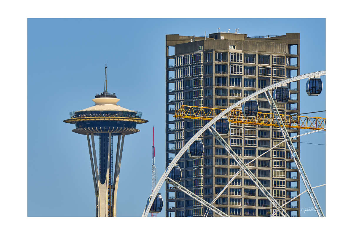
The Space Needle, Seattle, WA
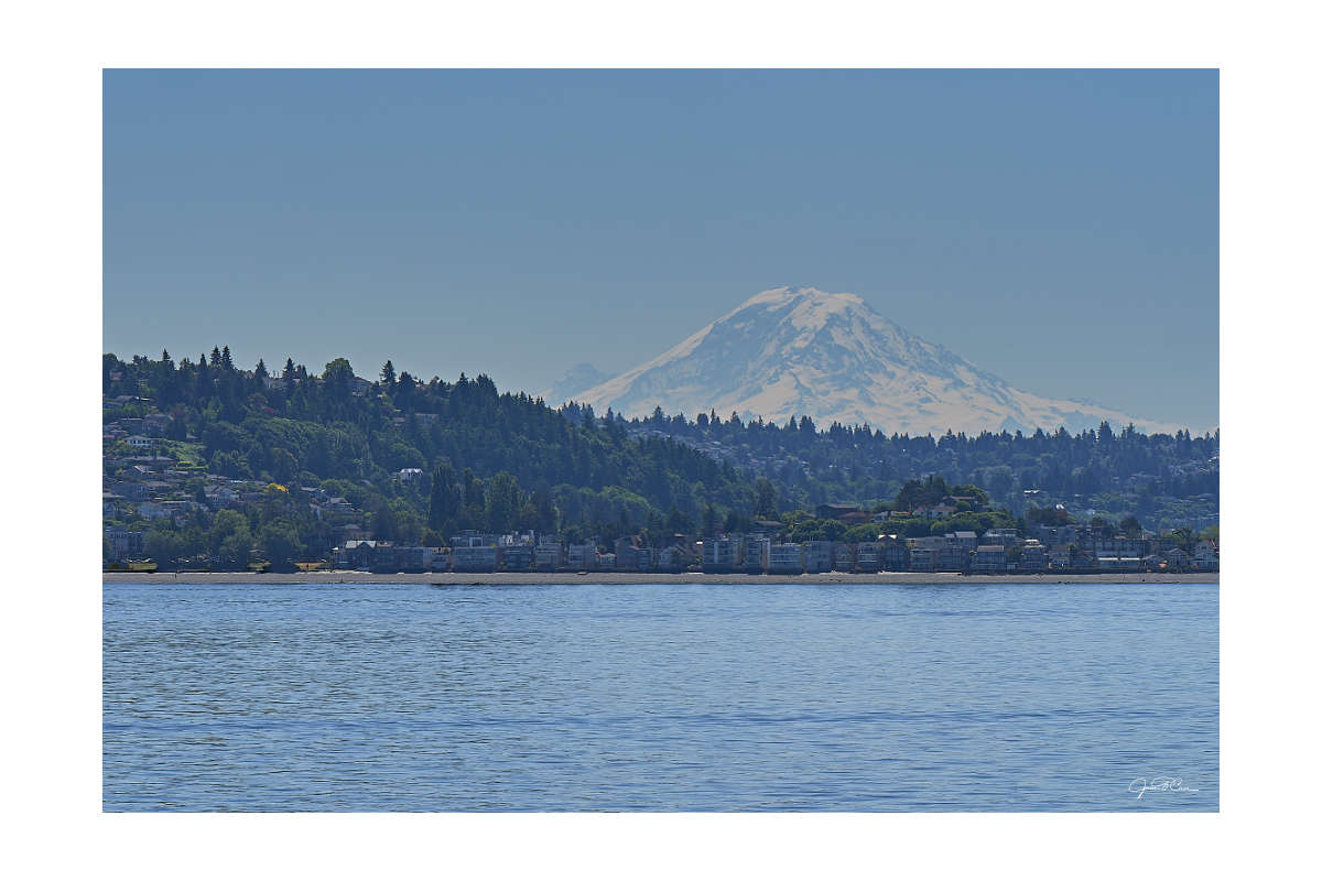
Mount Ranier, Seattle, WA
Northwest Oregon and the Washington Coast
The most important destinations on this two-week adventure were Cannon Beach and Astoria, Oregon. Many people my age know them from The Goonies, and childhood nostalgia was a large part of my reason for visiting. They are famous in their own right, though, and typical of the rocky beaches and small towns that pepper the Oregon coast. I spent an amazing afternoon and evening in the area. The highlight of the entire trip was watching the sun disappear behind the Pacific Ocean at Haystack Rock. It was an amazing experience.
Read about my visit to Cannon Beach
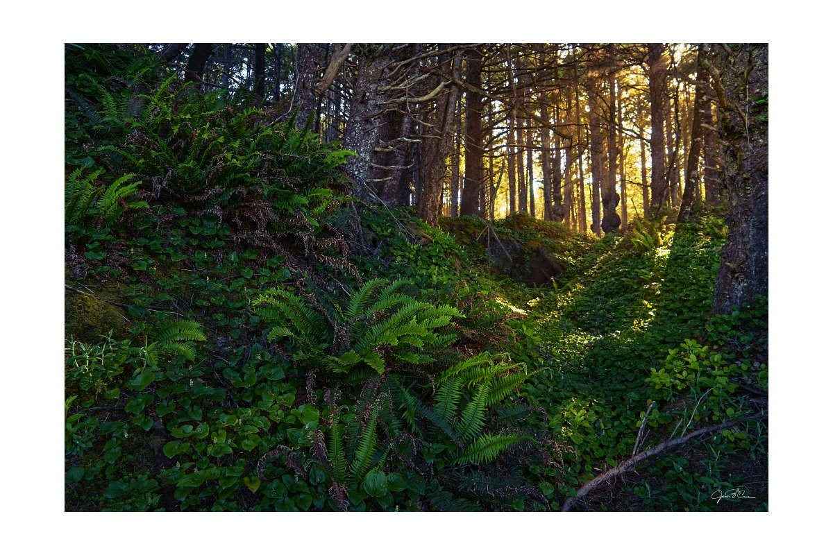
After another night of sleeping in the car, I was up early and on my way north. The last adventure on the West Coast was a quick loop around Washington State’s Olympic Peninsula. Hoh Rainforest in Olympic National Park was one of my must-see destinations. It was amazing, but Kallaloch Beach and Rubie Beach stole the show. The entire Olympic National Park and National Forest are both places I would like to explore more thoroughly.
Before I embarked on my trip, I had no idea what to expect. Now that I know more about the Olympic Peninsula, I want to spend as much time there as possible. Even after visits to Kallaloch, Ruby Beach, Hoh Rainforest, and Crystal lake and Marymere Falls, I feel like I’ve just barely scratched the surface. I hope to return soon to explore more remote parts of the peninsula. What I did see deserves its own post, though. That will be coming in the future.
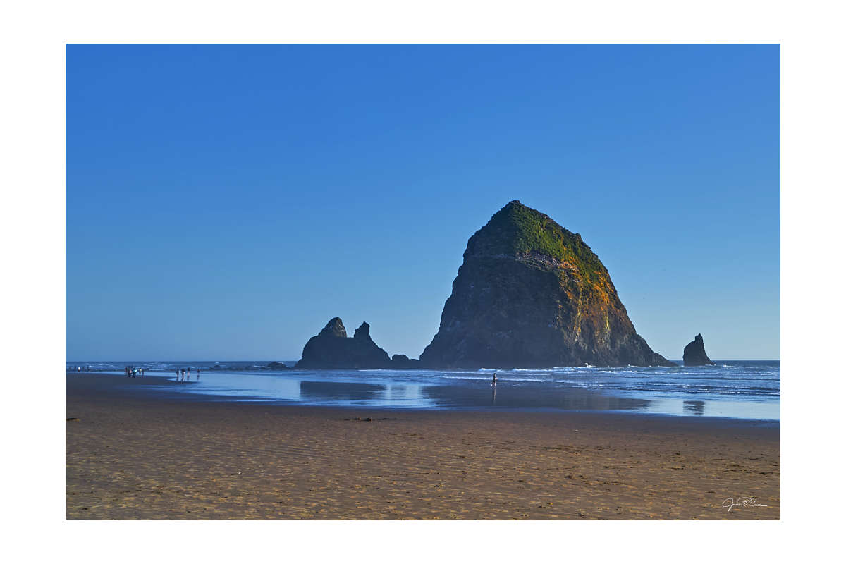
Haystack Rock in the late afternoon, Cannon Beach, OR
Giant ferns and trees in the coastal rainforest, Kalaloch Beach, Olympic National Park
The Sprint Home
I would cover about 2850 miles in only about two and a half days. Fortunately, my route through northeastern Oregon, Idaho, Nevada, Utah, and southern Wyoming would provide some amazing roadside scenery for my dash back to Pittsburgh. Most of the trip home felt desolate, especially once I crossed into northeastern Nevada on US Route 93. There isn’t much to see but the high desert between Jackpot and Wells. The last of the day’s sun left me during this leg of the journey and the landscape faded to meet the dark outline of the distant mountains.
I still had one more planned stop on my trip — the Bonneville Salt Flats. This place was etched into my mind by the images of Bonneville Speed Week in my father’s Hot Rod magazines. Through much of the winter, the salt flats are covered in a thin layer of water. By the middle of the summer, the harsh sun bakes away all the moisture, exposing the smooth, salty surface. I exited Interstate 80 after 11 PM and made my way out to the nearly four-mile-long raised roadway to the Bonneville Salt Flats sign. Even though the lights from Wendover and Salt Lake City were visible, I don’t think I had a more spectacular view of the night sky during my trip. The silhouetted landscape was covered in a thick blanket of bright stars. After enjoying the evening for about an hour, I found a popular boondocking site above the flats and got some much-needed rest.
I woke up early the next morning and drove back down to the Salt Flats sign for sunrise. It was Saturday and a little more crowded than I had hoped. Cars were lined up around the perimeter of the parking area, waiting for the first rays of sunshine to crest the horizon. After a beautiful blue hour, the golden light began to fill the sky.
If you are ever headed west on Interstate 80 through Utah and Nevada, at least stop for a few minutes at the westbound Salt Flats rest area to take in the view or even walk (or wade, depending on the time of year) out into the flats. It is a beautiful and amazing place. America’s national parks get most of the attention, but the Bureau of Land Management provides mostly free access to many thousands of acres of beautiful places across the country, like Bonneville Salt Flats. Many of these locations also permit free and long-term camping. It is an often-overlooked alternative or addition to busy state and national parks.
I spent the last night in my car at a rest stop just west of the Platte River. It had rained during most of my drive through Nebraska and the sound of the raindrops on the roof helped me nod off quickly. Before I knew it, I was awake and back on the road home. Fourteen hours later, I was back in Pittsburgh, exhausted and ready for bed.
My trip across the country was more of an adventure than a vacation. It was an opportunity to learn and grow — and to take some great photos of beautiful places. I learned that I still love isolated places, and I haven’t lost my childhood desire to get lost in the wilderness. Now, I also love tall mountains, giant trees, and rocky beaches. I want to see more…and I can’t wait to get back out on the road.
A patchwork of cultivated fields near Pendleton, Oregon.
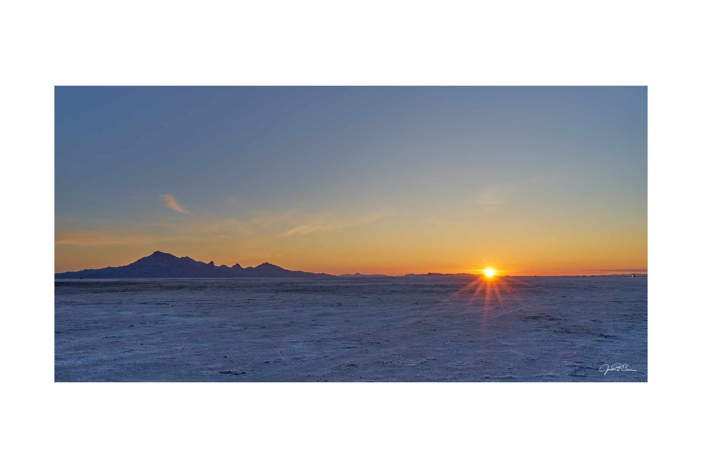
The sun rises creating a fiery red horizon at Bonneville Salt Flats in Utah.
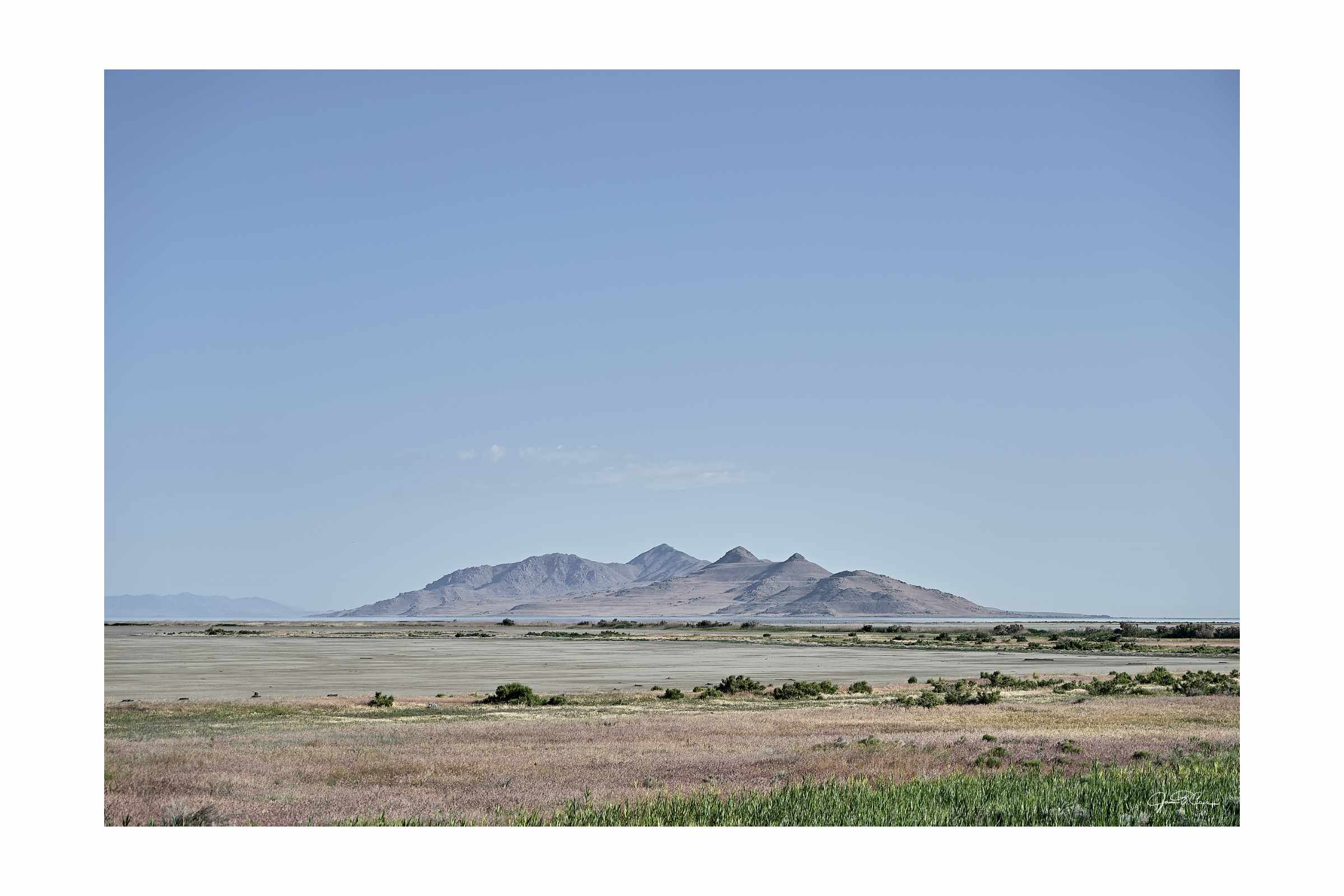
Antelope Island in the rapidly receding Great Salt Lake, Utah.
The dramatic desert landscape along Interstate 80, east of Salt Lake City, Utah.
Mapping the Journey
From Pittsburgh, the trip west began from I-376 to Interstate 79, then Interstate 70 through Ohio and Indiana. Interstate 74 and Interstate 39 led northwest through Indiana, Illinois, and southern Wisconsin prior to departing for more comfortable two-lane roads like US Route 14 and Wisconsin State Route 23 past Frank Lloyd Wright's Taliesin and toward Interstate 90 into Minnesota and across South Dakota to the Badlands and Rapid City.
A second visit to the Badlands started a drive down South Dakota State Route 44 to the Interior entrance to the park and a drive back to Interstate 90. US Route 16 and 16A were the route back through Rapid City, by Mount Rushmore, and to Custer State Park and Needles Scenic Highway. The backroads of South Dakota eventually led to to Spearfish Canyon Scenic Byway (US Route 85) via US Route 16 and 385 before stopping for the night at the Interstate 90 rest area in Sundance , Wyoming.
The next day began with a pre-dawn drive on US Route 14 and Wyoming State Route 24 for sunrise at Devils tower, prior to continuing west on US 14 and Interstate 90 into Montana. West of Bozeman, I-90 was left behind for Montana 287 and US Route 12 through Helena and later, Montana 141, 200, 83, and 82, and US Route 93 through the Montana backcountry to the edge of Flathead Lake. From there, it was on to Kalispell and Columbia Falls via US Route 93, Montana Route 40, and US Route 2 before boondocking for the night at Hungry Horse Reservoir.
An short drive farther down US Route 2 resulted in an early morning arrival at the West Glacier entrance of Glacier National Park for a short drive along the eastern shore of Lake McDonald on Going to the Sun Road. Next was a quick trip up Camas Road for an elevated view of the lake and mountains beyond before a short visit to Apgar Village. Then it was on to northern Idaho and Lake Pend Oreille via US Route 2/95, through Kootenai National Forest and Sandpoint. Main roads were quickly forgotten after turning off of Idaho Route 54, south of Bayview, Idaho and onto Forest Service roads on the way to Lakeview for a break from the road.
After two days on the lake, it was back down the unpaved Forest Service roads, set on Idaho Route 54, and South on US Route 95 and Idaho 53 and 41 to rejoin I-95 through Spokane. A late decision to visit the Palouse Hills and Palouse Falls caused a delayed exit from I-90/US 395 at Sprague for a southeasterly route to Steptoe Butte via Washington Route 23 and various county routes through the town of Steptoe and into Steptoe Butte State Park. From there the US 195 and Washington Route 26 and 261 were the route west and south to Palouse Falls State Park. After a brief visit, it was back to WA 261 North and WA 26 West across the desert, then farmlands of the Columbia Valley before rejoining I-90 at the Columbia River for the final leg of the trip to Seattle through the Cascades.
After recovering and exploring Seattle and Bainbridge Island, it was back to the road on Interstate past Tacoma and to the town of Longview, Washington and across the Lewis and Clark Bridge to US Route 30. Miles of road gently winding roads over rolling hills, parallel to the Columbia River, lead to Astoria, Oregon and the storied Highway 101, then south to Cannon Beach. After an evening in the car at Dismal Nitch restaurant area, just on the Washington side of the Columbia River, it was back to the 101. Kallaloch, Ruby Beach, a detour from 101 to Hoh Rainforest, and a hike from Crescent Lake to Marymere Falls completed the Olympic Peninsula sightseeing before counting the loop through Forks and Port Angeles and down WA 3, WA 16, and WA 160 to cross the Puget Sound on the Ferry from Southworth at sunset.
The Road back to Pittsburgh was fast, starting on I-5, then to I-90, US 95/I-82 through Yakima and past Kennewick, OR and over the Columbia River to US 30/I-84 through southwest Idaho before exiting onto I-93 at Twinn Falls and crossing into Nevada at Jackpot. A desolate drive through the desolate high desert ended at Interstate 80 in Wells, Nevada for a short drive to Bonneville Salt Flats for some stargazing and a night of sleep. Watching sunrise at Bonneville Speedway was the last major stop before a brief visit to the edge of the Great Salt Lake along Interstates 80 and 15 before heading east on I-84 to rejoin I-80 for the final sprint home through Wyoming, Nebraska (stopping west of the Platte River for sleep at a rest area), Iowa. Interstate 74 carried me through northern IIlinois and to Indianapolis, where I rejoined Interstate 70 for the trip through Ohio, before exiting onto US Route 22 to through the West Virginia northern panhandle and into Pennsylvania. The familiar I-376 and US 19 landed me back home on Pittsburgh's North Side.